Why the famed Appalachian Trail keeps getting longer — and harder
As America has transformed, so too has its celebrated footpath. Less than half the A.T. remains where it was originally laid.
MCAFEE KNOB, Va. — The morning fog had just begun to clear as the hikers made their way uphill, beckoned by a series of white blazes splashed on the trunks of hardwood and tall pine, the paint cracked where the bark rippled and whorled.
It was a weekday in mid-May on the Appalachian Trail, and their footsteps were muffled by the forest. Away they hiked — from the cramped parking lot glittering with vehicles, from the frenetic buzz of highway traffic, from the busyness and anxiety that compel people to step out of their lives, if only for a few hours, and escape into the wilderness.
Here, on what everyone calls the A.T., it was quieter. The leaves on the oaks were pearled with rain. Mushrooms erupted from softened logs, and in the crepey mass of damp leaves on the ground, roses and purple irises bloomed, sweetening the air.
One woman, a sweatshirt tied around her waist, pulled at the retractable leash of her German shepherd. She passed two brown-haired sisters in oversize T-shirts, hunched beneath the weight of their backpacks. With each step, their cooking pans tinkled like wind chimes. They paused beside a device that counts the hikers passing by on the trail.
“Did you know?” a sign read. “McAfee Knob is considered the most photographed spot on the Appalachian Trail.”
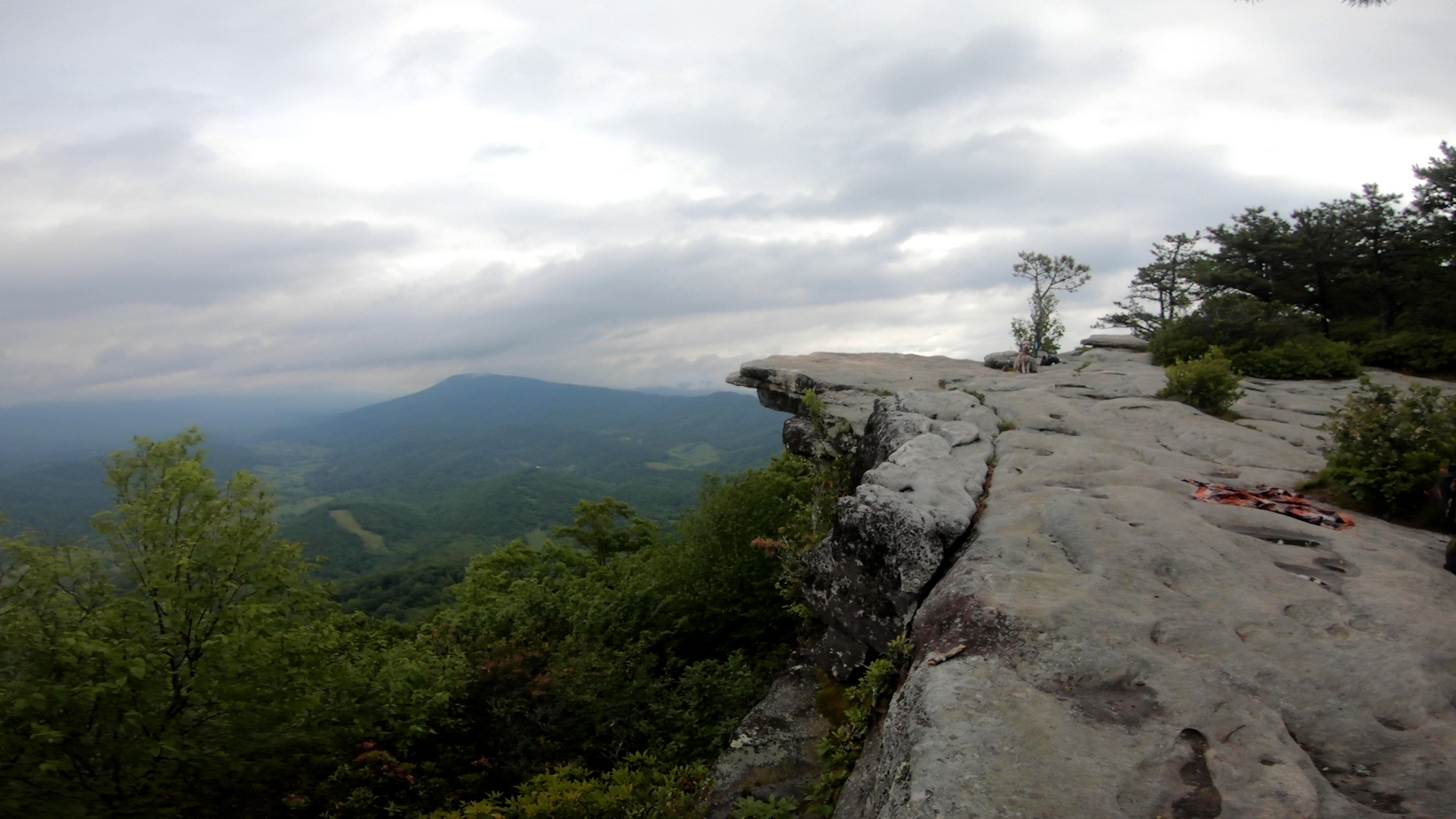
Four more miles uphill was the landmark, where hikers meet the open sky. The rocky ledge — at 3,200 feet — resembles a diving board. In the valley below, creeks slanted through the green. There were pinpricks of farms and shaved fields. The vast ocean of Jefferson National Forest lapped the horizon.
This panorama atop Catawba Mountain draws more than 50,000 people each year, causing a logjam and necessitating a seasonal shuttle to the trailhead on weekends.
“Once at the top, you can’t put words to it,” one hiker wrote on the popular outdoor website AllTrails.
But for almost a decade, McAfee Knob wasn’t part of the A.T. at all.
Much of the mountain was privately owned, and the landowners — fed up with trash and bad hiker behavior — became reluctant to let visitors onto their properties. So from 1978 to 1987, they didn’t. The trail was relocated onto a nearby, less scenic mountain, until the National Park Service used eminent domain to return the vista to the A.T. experience.
“I can’t believe it,” said Austin Stewart, 21, standing atop McAfee Knob with his girlfriend, Beyla Richman, 22. “It’s one of the few things I’d heard about the trail.”
“It’s crazy this wasn’t on it before,” Richman agreed.
Though fixed in the public imagination, the world-famous footpath, which stretches from Georgia to Maine, has been stretched, shrunk, rerouted and redesigned since it was declared complete in 1937.
As America has transformed, so, too, has the A.T. — changes that have inspired resistance, ridicule and relief. Originally 2,050 miles, it is now almost 2,200 miles. And it continues to get longer.


By many historians’ estimate, less than half of the trail remains where it was originally laid.
The southern terminus in Georgia was moved from one mountaintop to another, 37 miles away.
More than 300 miles of trail in Virginia was discarded.
A ribbon of the path along a suburban highway near Washington was abandoned for steep wilderness terrain resembling a roller coaster.
More than half of the A.T. in Maine was rerouted.
“I’m going to guess there have been 1,500 to 2,000 modifications to the trail’s route, and most of them are so small that you wouldn’t be able to really see it on a screen,” said Mills Kelly, a professor at George Mason University who studies the A.T. The author of “Virginia’s Lost Appalachian Trail,” Kelly also hosts a podcast called “The Green Tunnel,” a reference to the trail’s heavy tree cover.
Those adjustments — crisscrossing 14 states, eight national forests and the ancestral lands of 22 Native American tribes, most of them forcibly removed by the government in the 1800s — have left cartographers at the Park Service struggling to keep up. Past iterations are often forgotten, their blueprints scattered among more than 30 local trail clubs, stored in plastic tubs in the basement of a former club president, glued to vellum at one club’s office in Vienna, Va., and in a new archive at George Mason University.
The Washington Post tracked down some of the biggest changes to the A.T. over the past 86 years, charting how it has been reimagined for 3 million annual visitors and the tens of thousands who have committed months to hiking its entirety.
Atop McAfee Knob, a wave of hikers spilled onto the viewpoint. A group of retired firefighters — training for a summit of Mount Rainier — took turns snapping photos on the outcropping, which, from the right angle, made them appear to hover over thin air.
In the distance, the mountains flushed blue-green. A spring storm was pressing down; the air was wet with humidity. The hikers rested, some for a few minutes, some for an hour, as the rain churned closer.
Then they continued on, the trail urging them forward.


Mount Oglethorpe to Springer Mountain
2,198.4 MILES TO MOUNT KATAHDIN, MAINE — LACE UP YOUR BOOTS AND LET’S GO!
The chickens, of course, ruined it.
It was 1958, and a decision had to be made — leave the A.T.’s southern terminus in Georgia on Mount Oglethorpe or move it north to Springer Mountain, snipping off the first 37 miles of trail.
By this point, it had been more than 20 years since the trail’s completion. Only a handful of people had hiked its entirety, but they tended to start at the 38-foot-tall monument atop Mount Oglethorpe. Carved from local marble, the obelisk was skinny and pale, resembling the Washington Monument in miniature. It’s where Earl Shaffer — a World War II veteran and the first person recognized to have completed the entire A.T. — began his journey in 1948, challenging the perception of what was possible.
[He lost his best friend in WWII. A trailblazing hike helped him heal.]

But now, the big issue was the chickens.
There were so many of them.
And they smelled awful.
“Hikers didn’t want anything to do with that,” Kelly said.
There were reasons other than the chicken farms, too. Vacation homes were popping up like an invasive weed. Timber companies were clipping through the forest, leaving sections bald and exposed. Old-timers in the area operated illicit distilleries — one spot on the trail had been nicknamed “Moonshine Mountain” — and were often unfriendly to hikers.
“The destroyed wilderness and the possibility of being shot at greatly impacted the use of Appalachian Trail in our area,” wrote local historians Don and Diane Wells in a post for the Mt. Oglethorpe Foundation’s website.
It wasn’t the first time tensions had arisen over where the A.T. should start and end. The question had plagued trail officials since the path was first proposed by Benton MacKaye — a forester and regional planner from Massachusetts — in a 1921 essay.

Grief-stricken by his wife’s recent suicide, MacKaye dreamed of carving out a footpath where city-dwellers could deal with “the problem of living.” He proposed a 1,200-mile trail stretching from the highest point in the Northeast — Mount Washington in New Hampshire — to the highest point in the South — Mount Mitchell in North Carolina.
The objectives, MacKaye said, were “(1) to walk, (2) to see, (3) to see what you see.”
With the help of Myron Avery — an admiralty lawyer at the U.S. Maritime Commission in Washington — the A.T. reached completion 16 years later. Avery, a native of Maine, insisted the trail end on Mount Katahdin, not Mount Washington.
He and MacKaye also clashed over what the trail should be. MacKaye favored wilderness at all costs. Avery preferred a complete, unbroken path, regardless of location.
“You are for a connected trail — whether or not wilderness,” MacKaye wrote to Avery in a 1935 letter. “I am for a wilderness trail — whether or not connected.”

By the end of their lives, they’d stopped talking to each other. Neither could have imagined how the footpath would continue to morph over the decades.
“The precise length of the Appalachian Trail is a matter of interesting uncertainty,” Bill Bryson wrote in his 1998 best-selling book about the A.T., “A Walk in the Woods.” He listed a range of figures from different sources before concluding, “What is certain is that it is a long way, and from either end it is not easy.”
There’s a certain calculus to deciding where — and when — to move the A.T., said Sandi Marra, president of the Appalachian Trail Conservancy, the nonprofit organization that manages the footpath in partnership with the Park Service and local trail clubs.
“Any time we do any kind of relocation, the litmus test we put it through is: Is this going to enhance and improve the hiker experience?” Marra said.
In the case of Mount Oglethorpe, eliminating the first three dozen or so miles made sense. In 1958, trail officials voted to shift the terminus to Springer Mountain, tucked in Chattahoochee National Forest — a place that was greener.
It was also better-smelling.
The Lost Appalachian Trail
1,700 MILES TO MOUNT KATAHDIN — UH-OH, DON’T GET LOST!
Few people remember that this 300-mile stretch of trail in Virginia ever existed.
Traversing the southwestern corner of the state, this section of the A.T. — which once made up about 15 percent of the trail’s total mileage — was among the last pieces slotted into place before the footpath’s completion. Passing through Iron Mountain and the Pinnacles of Dan, the area was so remote that it had proved difficult for trail leaders to visualize. They were forced to puzzle over topographic maps so old that some dated to the Civil War.

They settled on laying the trail over abandoned or gravel roads, opting not to include McAfee Knob in the original trail proposal, though it was later modified to include the landmark.
Nearly as soon as the trail was set, it began to move again.
“So the western half was on protected federal land, but the eastern half wasn’t, and it kept moving around because of that,” Kelly, author of “Virginia’s Lost Appalachian Trail,” explained in an episode of his podcast.
In the 1930s, the Park Service began building the Blue Ridge Parkway along more than 100 miles of the A.T. MacKaye and other trail leaders worried about the A.T.’s sudden proximity to construction, traffic and other markers of civilization. The point of the trail, after all, was to escape those reminders of urban life.
They wanted to move the trail into the protective embrace of the Jefferson National Forest. In 1952, the conservancy shifted the trail west of Blacksburg, where it remains to this day. The original markers were torn down. The hiking books were amended.
The old trail, it seemed, vanished.
The rise of the Roller Coaster
1,180 MILES TO MOUNT KATAHDIN — BEWARE THE TRAIL BOSS!
You’ll see the warning first.
“YOU ARE ABOUT TO ENTER THE ROLLER COASTER,” announces the sign, laminated and stapled to a trail marker. “ … HAVE A GREAT RIDE.”
Then come 13 miles of rolling hills — 3,800 feet up and 3,720 feet down, to be exact. Stretched between Ashby Gap and Snickers Gap in Northern Virginia, the Roller Coaster was the solution to a lot of concrete-walking.
A half-century earlier, the A.T. had been bumped onto a 15-mile stretch of highway shoulder. Then, in the 1980s, trail officials began working to purchase a sliver of land that felt wilder.


At only 1,000 feet wide, the corridor the Park Service eventually purchased didn’t leave much to work with, but it would have to do. Chris Brunton, a hiking enthusiast and member of the Potomac Appalachian Trail Club, was called in to help reimagine the route.
“To be honest with you, it was not a well-laid trail,” said Brunton, who goes by the nickname “Trailboss.” “We were confined because the Park Service bought only so much land. We did the best we could within that narrow corridor.”
The resulting trail was so hilly that out-of-breath hikers started calling it the Roller Coaster.
“How many miles and feet of elevation change can you get through in a day without dying?” demanded Kyle Putnam, 28, as he and his wife and a friend traversed the Roller Coaster on a spring morning.
Brunton is used to fielding criticism of his creation.
“At Harpers Ferry, hikers will come over and say, ‘Why did you make that so difficult?’ I’m the last one standing,” he said, “so I get the blame. I say, ‘You can walk the old trail. It’s still there. It’s 15 miles of walking along the road.’ They say, ‘Maybe not.’”
Palmerton: The A.T.’s former ‘Death Valley’
815 MILES TO MOUNT KATAHDIN — WELCOME TO ROCKSYLVANIA
It had taken two days to build this one step.
On a remote ridge above Pennsylvania’s Lehigh Valley, Ally Scholtz crouched over a jumble of rocks, pouring gravel around a boulder to stabilize it. It was a chilly day in mid-April, with bits of frozen rain spitting down from a gunmetal sky. The hillsides weren’t yet in bloom, and fog skulked around the mountains in the distance, sloped and faded.
Scholtz, 25, had spent much of the previous day dragging the boulder downhill, then aligning it with the others — one step in a staircase of many.
Someday soon, a hiker would easily climb up this scree, unaware of the time and effort it had taken to relocate the path here. They might even — mistakenly — think it had been around since the beginning of the A.T.

“If you want a small area with as many trail realignments crammed in as possible, you’re in the right place,” said Bob Sickley, a regional manager for the Appalachian Trail Conservancy.
Sickley, who was on the ridge to check on the trail construction crew, hiked at a brisk pace, pointing out places where you could still find the old A.T., if you looked hard enough. The white blazes had faded — but not completely. He motioned to a thick patch of forest. The old trail was right there! And also here! And there, too! Nearby, pink flagging in the pine marked where the new A.T. would soon go.

Part of the path, just north of Allentown, overlooks a zinc smelting operation that made the Environmental Protection Agency’s list of Superfund sites in 1983. The pollution blew onto the ridge, causing a massive vegetation die-off and leading to a decades-long cleanup.


Kurt A.T. Bodling, the library director of the Appalachian Trail Museum in nearby Pine Grove Furnace State Park, Pa., once described it as “Death Valley” — though remediation efforts over the years have helped a lot, he said.
“It was like you were wandering, looking for a waterhole, only to find it poisoned and a dead animal next to it,” Bodling said. “The zinc plant is why Palmerton looked like a desert.”

Sickley, more diplomatic, says that the area has struggled to confront this “external threat,” and that the new route — a total of 14 miles of trail work — will improve the hiker experience by delivering better vistas.
On the ridge, Scholtz continued stabilizing her boulder. Her jeans were streaked with dirt, and an orange construction hat bobbed on her head. She dreamed of hiking the entire A.T., but for now, the trail builder was content to just construct it, rock by rock.
“I’ll save it until I’m retired,” Scholtz said. “I can hike over pieces that I set when I was 25 — hopefully.”
Maine’s 100-mile wilderness
115 MILES TO MOUNT KATAHDIN — YOU’RE ALMOST THERE!
David Field remembers when more than half the trail in Maine wasn’t much of a trail at all.
The northern terminus of the A.T. — atop 5,269-foot Mount Katahdin — is gloriously unspoiled, But for decades, the 280-mile trail leading up to it needed work.
There was a big push to reroute it, said Field, 82.
Now retired from the School of Forest Resources at the University of Maine, Field has been the manager of lands for the Maine Appalachian Trail Club for 20 years and a member for even longer — 67 years.
When he was young, the volunteers and conservation crews who’d originally etched the path into the landscape mostly laid the trail on preexisting paths — old logging and fire-tower access roads — or along busy highways.

About 80 percent of the trail crossed land owned by nine major timber companies.
“The ATC leadership came close to abandoning the Maine section,” Field wrote in his 2011 book, “Along Maine’s Appalachian Trail.”
After the A.T. was placed under control of the Park Service in 1968, the federal agency bought more than 37,000 acres in Maine, whittling out a protective corridor for the trail.
About 14 miles of the trail were rerouted from Sugarloaf Mountain’s popular ski resort to nearby Crocker Mountain. An additional 15 miles was moved from a highway corridor — near Maine Routes 4 and 7 — and pushed through the forest. The last big move took the trail 16 miles into the woods, away from the Elliotsville Plantation.
The journey — through what felt like true wilderness, with boreal bogs, ponds of trout, gentle hills — ended atop Mount Katahdin.

“From the top of Mount Washington” — the original endpoint proposed by Benton MacKaye — “you’re looking down at roads full of cars and villages of people,” Field said. “From Katahdin, you look out at nothing. The mountain rises up out of the forest all by itself.”
It’s the place where so many thru-hikers end their journey — and where the endpoint will stay, vowed Hawk Metheny, vice president of trail management for the conservancy.
But not everyone agrees with that assertion.
Some have proposed extending the A.T. from Maine into Canada by adding New Brunswick and Quebec — a path already known as the “International Appalachian Trail” — and perhaps going even farther.
Others want the trail to begin in Alabama instead of Georgia, connecting the state’s tallest peak, Mount Cheaha, to Springer Mountain, 314 miles away. The “AT2AL” campaign has won the support of Alabama’s Department of Conservation.
“There’s something magical about the idea of linking Maine’s highest peak with Alabama’s highest mountain,” Chris Blankenship, the Alabama conservation commissioner, declared last year. “Hikers who complete this feat would have the satisfaction of having traveled the entire length of the Appalachian Mountains in America.”
The idea sent one Reddit thread devoted to the A.T. into a mini-meltdown, with one commenter objecting: “People will have to start hiking on New Year’s Day now to get it all done!”

Some thru-hikers already fret every time the trail gets longer, wondering if they can still claim to have hiked its entirety. The conservancy assures them that they can. And while the trail might not be exactly the same as it was in 1937 or 1967 0r 2007, the experience — of sticky summer nights in a tent, of gazing out at an overlook at the great expanse of America, of legs turned shaky by rocky ground, of endless mosquito bites, burrs and birdsong, of finding something of oneself in the Green Tunnel?
That will remain unchanged.

Congratulations, hiker!
Having completed the entire Appalachian Trail, you’re officially a member of the ‘2,000-Miler Club.’